The GEBCO 2025 grid is now available (released August 2025).
To select a region
Hold down the control (ctrl) key. Press and hold the left mouse button, then drag a box to select a region on the map.
On a Mac, use the Command key instead of ctrl.
This site uses cookies to analyze traffic.
Heading
Text
Heading
Text
Your data downloads basket
Preparing your basket for download
It will take a while to generate the download.
Please provide your email address and we will send you a download link when it's ready.
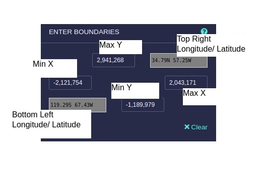
Enter boundaries
Use the blue boxes to enter the min and max bounding box values for your area of interest in projection co-ordinates (meters). The grey boxes show the equivalent geographic longitude and latitude values (decimal degrees) for the top right and lower left limit of the area.

Select formats
Formats help text
GRID NAME
GRID HELP TEXT
How to use the download tool
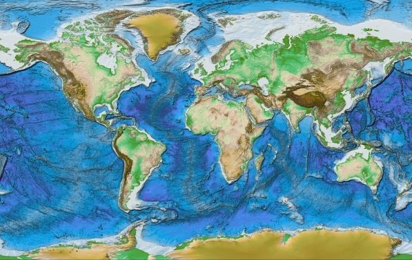
GEBCO’s global gridded bathymetric data sets are terrain models for ocean and land at 15 arc-second intervals. You can use this tool to download subsets from thee grids and their associated Type Identifier (TID) grid in a selection of widely supported formats.
Selecting a grid version
You can select which version of the grid that you want to download data for from the 'Select Grid Version' list. The '?'' button provides information about the selected grid version.
Selecting a region
A region is defined between two latitudes and two longitudes. Enter these manually in the input boxes provided, or select the region using the mouse. To use the mouse, hold down the CTRL key (Windows) or Command key (Mac). Then select the region by holding down the mouse button and dragging.
Download formats
You can download your data in netCDF, geoTIFF and Esri ASCII formats. Select the ones you want by checking the relevant boxes.
Download imagery based on the bathymetric grids
You can download imagery based on GEBCO’s grids in the form of shaded relief image or colour-coded for elevation image in either JPEG or PNG format. Select the ones you want by checking the relevant boxes.
Managing your basket
Once you have selected your region and formats, click the 'Add to basket' button. You can add more than one region to download at a time so if required select more regions and add them in the same way.
Downloading your data
Click 'View basket' when you are ready to download your data, or to manage the items you have added so far.
When you click 'Download your data', if the data can be delivered quickly it will be downloaded directly through your browser after a few seconds. If it will take longer to prepare you will be asked to provide your email address and we will email you a download link as soon as it is available.
You will get your data as a single ZIP file containing all of the regions you have requested.
About GEBCO
The General bathymetric Chart of the Oceans (GEBCO) consists of an international group of experts in ocean mapping. Our aim is to provide the most authoritative publicly-available bathymetry of the world's oceans.
Seabed 2030
The Nippon Foundation-GEBCO Seabed 2030 Project is a collaborative project between the Nippon Foundation of Japan and GEBCO. It aims to bring together all available bathymetric data to produce the definitive map of the world ocean floor by 2030 and make it available to all.
Seabed 2030 was launched at the United Nations (UN) Ocean Conference in June 2017 and is aligned with the UN's Sustainable Development Goal #14 to conserve and sustainably use the oceans, seas and marine resources.
GEBCO's data sets and products
GEBCO makes available a range of bathymetric data sets and products.
- Download the global GEBCO grid in netCDF format
- Access GEBCO’s Web Map Services
- Access the GEBCO Gazetteer of Undersea Feature Names
Other downloads
GEBCO 2024
If you need the full global GEBCO 2024 grid you can get it here.
You can download it as a single netCDF file, or a single download containing a set of eight 90 x 90 degree tiles, in either GeoTIFF or Esri ASCII format.
You can also download the accompanying Type Indentifier (TID) grid with the same options.

GEBCO 2024 Grid
With ice surface elevation
GEBCO 2024 Grid
With sub-ice topography/
bathymetry information
GEBCO 2024 TID grid
- Single netCDF
- 7.5GB | 4GB download
- 8 tiles, GeoTIFF format
- 8GB | 4GB download
- 8 tiles, Esri ASCII format
- 20GB | 5GB download
- Single netCDF
- 7.5GB | 4GB download
- 8 tiles, GeoTIFF format
- 8GB | 4GB download
- 8 tiles, Esri ASCII format
- 20GB | 5GB download
- Single netCDF
- 4GB | 90MB download
- 8 tiles, GeoTIFF format
- 7GB | 96MB download
- 8 tiles, Esri ASCII format
- 9.5GB | 108MB download
Further details about the data set and its terms of use, disclaimer and errata information are available from GEBCO’s web site.
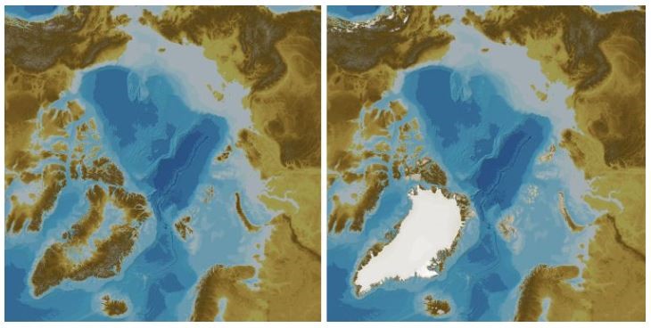
International Bathymetric Chart of the Arctic Ocean (IBCAO) V5
Access version 5 of the IBCAO data set. The data are made available in Polar Stereographic projection co-ordinates (meters), true scale set at 75°N (EPSG:3996). The horizontal datum is WGS 84 and vertical datum can assumed to be Mean Sea Level (however, note there may be datum issues for older data, which can be to chart datum). Further details are available on the IBCAO page on GEBCO's web site.

Download data as 100m x 100m; 200m x 200m or 400m x 400m interval grid files with an accompanying data source Type Identifier (TID) Grid for the 100m x 100m interval grid. Data files are in GeoTiff format with elevation values in meters (floating point).
Without elevation data for the Greenland Ice Sheet
https://www.bodc.ac.uk/data/open_download/ibcao/ibcao_v5_100m/geotiff/100m x 100m grid
- GeoTIFF format
- 11.4GB download, 13.5GB uncompressed
200m x 200m TID grid
- GeoTIFF format
- 3GB download, 3.3GB uncompressed
400m x 400m grid
- GeoTIFF format
- 1GB download, 1GB uncompressed
With elevation data for the Greenland Ice Sheet
100m x 100m grid
- GeoTIFF format
- 12GB download, 27GB uncompressed
200m x 200m grid
- GeoTIFF format
- 6GB download, 7GB uncompressed
400m x 400m grid
- GeoTIFF format
- 1.5GB download, 1.7GB uncompressed
Type Identifier (TID) grid
100m x 100m grid
- GeoTIFF format
- 0.3GB download, 3.3GB uncompressed
Downloading data indicates that the user accepts the disclaimer information.


